Home
About us
HK intro
Easy Walk
River
Hiking
Coastine
Caving
Overseas
Gallery
Join us
Hiking tips
Other sites
Publicity
Contact us
Outdoor Doctor
FaceBook Group
Order FREE HK Travel Brochure!

Visitors

since April 2000
|
North Heaven Gate (北天門)
Difficulty:

Last Visit:
Jan 2002
Lantau

Trip Description
North Heaven Gate is one of the three Gates of the Phoenix (Lantau Peak). The other two gates are South Heaven Gate and Feng Bi Stream (Phoenix Wall Stream). It is located in north-eastern part of Lantau Peak. There are at least three routes leading to North Heaven Gate. The first route is to go up the ridge of the mountain via Tei Tong Tsai (地塘仔), and head toward Lo Hon Tower (Route B). Then you can observe North Heaven Gate closely there. Another one, which is the easiest way, is to start an the pavilion west to Tei Tong Chai, and where you can find some graves. The route goes along a clear route up to Lo Hon Tower too (Route C).
The one described here is the most difficult one, and most direct one (Route A). It is to going through Tsoi Stream (曹溪)(Tsoi means Yin Tsoi, meaning the death world) and the North Heaven Gate River, where you by-pass Lo Hon Tower, and end up between the trough between the main Lantau Peak (934m) and the second (associate) Lantau Peak (918m). You can start to walk up the hill via Shek Mun Kap passing through Lo Ho Monastery. You have to walk up the stairs up to Tei Tong Tsai, where you will see two bridges.
|
Location 1: Altitude 230M
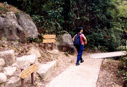 This is the first bridge. You can see signs showing both direction. This is the first bridge. You can see signs showing both direction.
|
Location 2: Altitude 240M
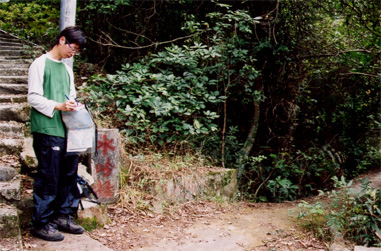 It is the second bridge, called "Shui Yam" Bridge (some people also called Tsoi Stream as Shui Yam Stream. Get into the shallow river down the bridge. There are ruins of temples of Tei Tong Tsai near the entry area. The river goes up quite quickly, and you find yourself under trees. It is the second bridge, called "Shui Yam" Bridge (some people also called Tsoi Stream as Shui Yam Stream. Get into the shallow river down the bridge. There are ruins of temples of Tei Tong Tsai near the entry area. The river goes up quite quickly, and you find yourself under trees.
You may choose to enter the stream by the third bridge at about 285m. The third bridge is shown below and is known as Yun Du Bridge (枟度橋).
|
Location 3: Altitude 400M
 If you head toward the correct direction, you will start to encounter some small waterfalls (almost no water) and cliffs around 400-500m. The general rule of this part is to keep a little bit right before you go out of the forest. Some hikers have already stood up fences or strings baring the incorrect path that are mostly on the left sides. If you head toward the correct direction, you will start to encounter some small waterfalls (almost no water) and cliffs around 400-500m. The general rule of this part is to keep a little bit right before you go out of the forest. Some hikers have already stood up fences or strings baring the incorrect path that are mostly on the left sides.
|
Location 4: Altitude 500M
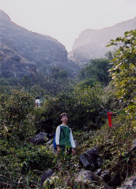 You finally exit out of the forest. As you can see on the photos, there are red ribbons guiding your way. In the photo, you can see the whole picture of Crouching Budda Cliff at the background. In fact, valley in the middle of the Budda is the North Heaven gate. In general, the left side is characterized by some pieces of green pastures on a sharp cliff while the right side is a rocky area. You finally exit out of the forest. As you can see on the photos, there are red ribbons guiding your way. In the photo, you can see the whole picture of Crouching Budda Cliff at the background. In fact, valley in the middle of the Budda is the North Heaven gate. In general, the left side is characterized by some pieces of green pastures on a sharp cliff while the right side is a rocky area.
|
Location 5: Altitude 550M
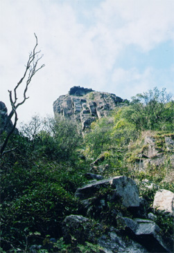 After some easy climbs, you will go into Lo Hon Valley. Looking up, you will see Lo Hon Tower which is however still far away at around 810m. The valley is also the only way to North Heaven Gate. After some easy climbs, you will go into Lo Hon Valley. Looking up, you will see Lo Hon Tower which is however still far away at around 810m. The valley is also the only way to North Heaven Gate.
|
Location 6: Altitude 820M
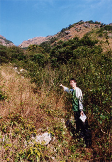 Passing through the valley, you have already entered North Heaven Gate and you will soon discover the wide, open scenery of the valley in front is soon replaced by sharp uprising cliffs. This area is called Horseshoe Mouth. And you will suddenly find yourself end up in the bottom of a cascade which is wet and almost impossible to overcome. The key is to look at your right side, where the hiker is pointing at. You have to walking through the grassland a few steps. This part is the tummy of the Crouching Budda. Passing through the valley, you have already entered North Heaven Gate and you will soon discover the wide, open scenery of the valley in front is soon replaced by sharp uprising cliffs. This area is called Horseshoe Mouth. And you will suddenly find yourself end up in the bottom of a cascade which is wet and almost impossible to overcome. The key is to look at your right side, where the hiker is pointing at. You have to walking through the grassland a few steps. This part is the tummy of the Crouching Budda.
|
Location 7: Altitude 830M
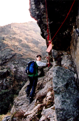 All of a sudden, you will see the North Heaven Gate in front of you. This is the most dangerous path. If you are not experienced, go back. You have to walk across it horizontally with some ropes and hooks left by pioneers. If these ropes didn't exist, the path could have been ranked as a five-star route. There are red ribbons guiding you to the left side of the Horseshoe. Be careful here, we saw some white ribbons which head towards Lo Hon Tower instead. All of a sudden, you will see the North Heaven Gate in front of you. This is the most dangerous path. If you are not experienced, go back. You have to walk across it horizontally with some ropes and hooks left by pioneers. If these ropes didn't exist, the path could have been ranked as a five-star route. There are red ribbons guiding you to the left side of the Horseshoe. Be careful here, we saw some white ribbons which head towards Lo Hon Tower instead.
|
Location 8: Altitude 900M
 After walking up some grassy slopes of the left side of the Horseshoe (also the Budda), you will be in-between the Lantau Peak and its associate Peak. It is a very windy place. Because the weather can change drastically here, the altitude we measured here might not be as exact as other trails.
As a tourist, normally, people go to visit the two peaks to enjoy the and then go down through the Lautau Peak Rocky Stream (Fung Fung Shek River) down to the Lantau Trail. After walking up some grassy slopes of the left side of the Horseshoe (also the Budda), you will be in-between the Lantau Peak and its associate Peak. It is a very windy place. Because the weather can change drastically here, the altitude we measured here might not be as exact as other trails.
As a tourist, normally, people go to visit the two peaks to enjoy the and then go down through the Lautau Peak Rocky Stream (Fung Fung Shek River) down to the Lantau Trail.
|


|
|
